


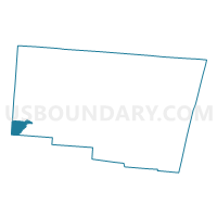
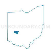
Voting District BETHEL 1, Clark County, Ohio
About
Outline

Summary
| Unique Area Identifier | 643408 |
| Name | Voting District BETHEL 1 |
| County | Clark County |
| State | Ohio |
| Area (square miles) | 3.78 |
| Land Area (square miles) | 3.35 |
| Water Area (square miles) | 0.43 |
| % of Land Area | 88.67 |
| % of Water Area | 11.33 |
| Latitude of the Internal Point | 39.86630820 |
| Longtitude of the Internal Point | -84.03457010 |
Maps

Graphs
Select a template below for downloading or customizing gragh for Voting District BETHEL 1, Clark County, Ohio


Neighbors
Neighoring Voting District (by Name) Neighboring Voting District on the Map
- Voting District BETHEL 2, Clark County, OH
- Voting District BETHEL 3, Clark County, OH
- Voting District BETHEL 4, Clark County, OH
- Voting District BETHEL 8, Clark County, OH
- Voting District BETHEL 9, Clark County, OH
- Voting District MR 1, Clark County, OH
- PRECINCT BATH TWP 276, Greene County, OH
- PRECINCT BETHEL SOUTH EAST, Miami County, OH
- PRECINCT HUBER HEIGHTS 6-A, Montgomery County, OH
- PRECINCT HUBER HEIGHTS 6-B, Montgomery County, OH
Top 10 Neighboring County Subdivision (by Population) Neighboring County Subdivision on the Map
- Bath township, Greene County, OH (39,392)
- Huber Heights city, Montgomery County, OH (37,142)
- Bethel township, Clark County, OH (18,523)
- Mad River township, Clark County, OH (11,156)
- Bethel township, Miami County, OH (4,843)
Top 10 Neighboring Place (by Population) Neighboring Place on the Map
Top 10 Neighboring Unified School District (by Population) Neighboring Unified School District on the Map
- Fairborn City School District, OH (41,848)
- Huber Heights City School District, OH (41,647)
- Tecumseh Local School District, OH (19,020)
- Greenon Local School District, OH (12,254)
- Bethel Local School District, OH (5,606)
Top 10 Neighboring State Legislative District Lower Chamber (by Population) Neighboring State Legislative District Lower Chamber on the Map
- State House District 70, OH (123,974)
- State House District 79, OH (119,858)
- State House District 40, OH (105,787)
- State House District 72, OH (102,568)
Top 10 Neighboring State Legislative District Upper Chamber (by Population) Neighboring State Legislative District Upper Chamber on the Map
Top 10 Neighboring 111th Congressional District (by Population) Neighboring 111th Congressional District on the Map
Top 10 Neighboring Census Tract (by Population) Neighboring Census Tract on the Map
- Census Tract 3801, Miami County, OH (5,802)
- Census Tract 1004, Montgomery County, OH (4,759)
- Census Tract 28, Clark County, OH (4,649)
- Census Tract 29.02, Clark County, OH (4,477)
- Census Tract 29.01, Clark County, OH (3,743)
- Census Tract 30.01, Clark County, OH (3,145)
- Census Tract 2803, Greene County, OH (1,832)